
Introduction
The movement of tectonic plates, the rising of magma along fault lines to the ground, and atmospheric pressure on layers of sediment led to our intensive collection of data. The data help us to know and identify how different geological features are formed in San Francisco Bay. The estimates from the data collected ranged from areas covered with soft rocks to areas covered with hard rocks. The data collected from this region are key to ensuring that it is accurate and appropriately comprehended. Hence, it may give a good idea of how most geological features are formed on the San Francisco Bay due to the tectonic plates’ movement, faulting, magma movement from the crust, and the intense atmospheric pressure on the overlying layers of sediments (Jaumé et al., 770).
Background
San Francisco Bay is the largest estuary on the west coast of the United States of America. The region around the bay has a number of geological deposits that can easily be noted from a close view. The deposits are said to have been at the bay for as long as more than one hundred million years, and basically, this is for the rocks that are on the ground. Rocks around the bay are basically formed through two major processes: metamorphosis and cretaceous formation. There are three sedimentary rocks: gabbro, diorite, and basalt. These three rocks were moved to land during the Jurassic period by the great influence of subduction on the continental margin. The cracks seen in the rocks were due to the depletion of mineral precipitates or crystals in the original homogeneous rock that resulted in the changing of the rock composition. These deposits form due to continuous weathering of the original rocks.
The rocks were formed underwater due to the subductions, and some parts of the rocks were moved to the surface by water, where they formed numerous layers and later hardened due to a lot of pressure exerted on them, so they became strong rocks. The mélange, which is a mixture of different rocks, formed in California through a process called the accretionary wedge. The process kept repeating itself, henceforth creating several layers in the wedge, which were further fractured, resulting in a mixture of rocks that became mixed into a mélange (Bufe et al., 9875). Many years later, the complete subduction of the Farallon plate under the North American plate near San Francisco resulted in the San Francisco complex.
Result
It is generally assumed that most of the metamorphic rocks were formed as a result of the collision of the tectonic plates that resulted in the plates sliding along the fault lines, and therefore created different forces, leading to an increase in heat flow and the breakage of rocks. Lines of weakness allowed magma from the crust to rise and pass through them. It is because of the high temperature applied to the rocks that the forces lead to the destruction of the rock structures, which leads to rock metamorphism.
The folding and faulting in the rock areas are due to the compressional forces applied to the rocks, leading to deformations. The Cretaceous sedimentary rocks were formed due to the deposition of the environmental rocks underwater, whereby water movement kept hitting the sediments from place to place; as they kept on moving, they underwent compaction, hence solidifying and hardening to sedimentary rocks.
Method
A comparison between two sets of data collection was made through the comparative time series, and peak motion observation was performed during the data collection. Both methods helped in appropriate estimation, recording, and final analysis of the data collected. These methods also helped in making simultaneous tests on the data collected and the intern probability that such correlation could be obtained by chance.
Conclusion
It is believed that along the San Francisco coastline, the sedimentary rocks are still forming due to the fact that there is still a lot of marine life in the water. Many marine organisms die and are buried over time to form huge organic layers. They are then subjected to intense pressure that compacts them together. Water is drained from them due to pressure, which also generates heat; later, the sediment particles stick together to form rocks. Similarly, water and wind may lead to the movement of sedimentary particles that are deposited along the coastline of San Francisco. Continued deposition of sediments may lead to the formation of layers, leading to hardening of the layers due to pressure, hence the formation of sedimentary rocks.
It is also believed that some of these rocks were formed beneath the water, but due to subduction, some parts of the rocks were pushed toward land by water and deposited along the bay.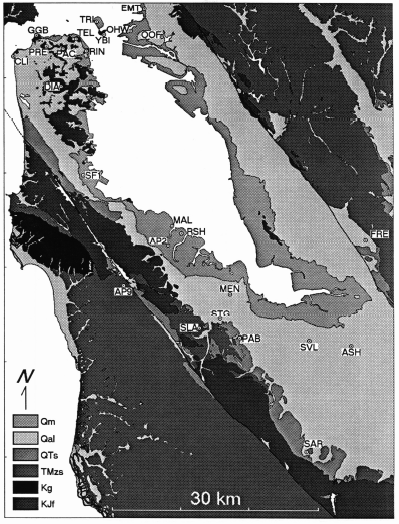
Works Cited
Bufe, Charles G., and David J. Varnes. “Predictive modeling of the seismic cycle of the greater San Francisco Bay region.” Journal of Geophysical Research: Solid Earth 98.B6 (1993): 9871-9883.
Jaumé, Steven C., and Lynn R. Sykes. “Evolution of moderate seismicity in the San Francisco Bay region, 1850 to 1993: Seismicity changes related to the occurrence of large and great earthquakes.” Journal of Geophysical Research: Solid Earth 101.B1 (1996): 765-789.
Sykes, Lynn R., and Steven C. Jaumé. “Seismic activity on neighbouring faults as a long-term precursor to large earthquakes in the San Francisco Bay area.” Nature 348.6302 (1990): 595.

Academic Master Education Team is a group of academic editors and subject specialists responsible for producing structured, research-backed essays across multiple disciplines. Each article is developed following Academic Master’s Editorial Policy and supported by credible academic references. The team ensures clarity, citation accuracy, and adherence to ethical academic writing standards
Content reviewed under Academic Master Editorial Policy.